The final two days of the bitter cold snap will likely see record-breaking temperatures.
Moose Jaw has seen one extreme cold record fall over the last week, and two more are almost certain to go this weekend.
Based on Environment Canada record-keeping dating back to 1943, the overnight low on Monday, Feb. 8 was the coldest in 77 years, hitting -35.8 C degrees to barely nip the old mark of -35.6 C.
The bitter cold is expected to last through Saturday, with the final two days of the polar vortex-caused snap bringing some of the most bitter cold of all.
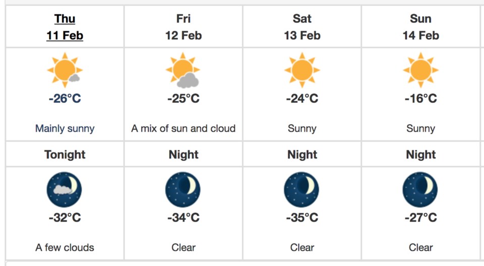
The record low for Feb. 11 of -33.3 C set in 1944 is expected to be threatened, with a predicted low of -32 C on Thursday night. Then, two records from the ‘70s will likely fall on Friday and Saturday.
The overnight low for Feb. 12 is expected to hit -34 C, which would easily break the old mark of -32.2 C set in 1975. That brutal night will be followed by an even colder one on Feb. 13, where the former record of -31.7 C will likely be easily smashed by the -35 C overnight low.
Daytime temperatures will also remain punishing, failing to clear -24 C any of the three days.
Of course, none of these take into account windchill, which will hover in the -45 C range all three days and cause frostbite in minutes.
Fortunately, Sunday will mark the beginning of a reprieve, with a low of -27 C and daytime high of -16 C. Temperatures will return to the normal range of highs in the -4 C range and lows of -15 C as early as the middle next week.


