MANITOBA CO-OPERATOR — The first month of summer has come and gone and for some regions there was too much rain — but for a large portion of the Prairies it continued to be on the dry side.
Looking at the temperatures, this is the first month since February where all the major reporting stations reported below-average values. Luckily, we were not as far below average as it was back in February.
Looking at July temperatures, it was a cooler-than-average month right across the Prairies, but with the exception of Saskatoon, most places were just slightly below average.
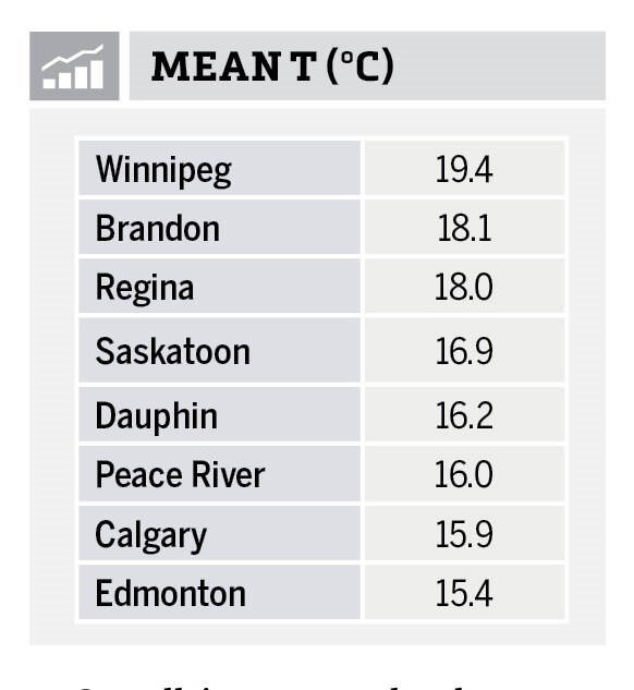
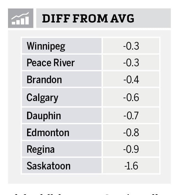
The warmest location by a fair amount was Winnipeg with a reading of 19.4 C. Winnipeg and Peace River were also the warmest locations when we look at the difference from average. Overall, the warmest regions were southern Manitoba and southern Saskatchewan. The cold spots in July were Edmonton and Calgary thanks partly to the wet conditions these regions experienced.
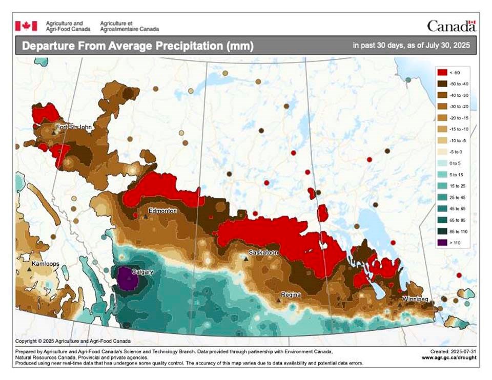
Which brings us to our look at precipitation. The numbers tell a story of just how dry some regions continue to be — but as I pointed out earlier, we can also see just how wet parts of southern and central Alberta were.
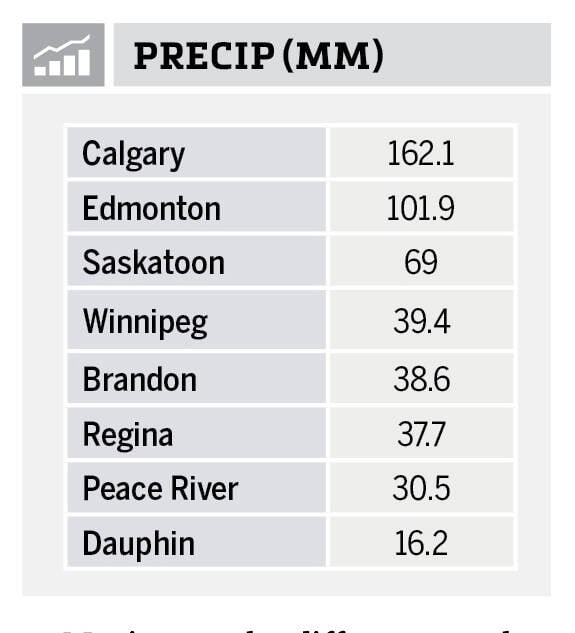
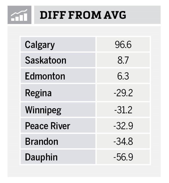
Looking at July’s precipitation you can quickly see that it was once again a dry month right across the Prairies with a few exceptions – Calgary, Saskatoon and Edmonton. These three locations all reported above average amounts with Calgary recording almost triple their long term average. Elsewhere, it remained dry with all the other reporting stations coming in with less than 40 mm of rainfall in the month.
If you look at the map of precipitation compared to average for July you can see that the main storm track for the month stretched from southern Alberta southeastwards into extreme southern Manitoba.
Overall, it was a cooler than average July with southern Alberta through to southern Manitoba seeing above-average rainfall, while the remainder of the Prairies continued to be dry.
If we look back at the different forecasts for the month, none of the forecasts were close as nearly all of them called for a warmer and drier than average month.
If we had to pick a winner, then I would have to go with the Canadian CanSIPS model as it called for below average temperatures in Manitoba with near average in Saskatchewan. So, while not that close, it was the only one that predicted any below average temperatures.
Fall 2025 weather outlook for the Canadian Prairies
Now on to our look at the last full month of summer and the start of the fall forecasts. Starting off as usual with our two almanacs. The Old Farmer’s Almanac is calling for below average temperatures in August followed be near to slightly above average temperatures in September and October. Along with the colder than average August, they are calling for above average precipitation.
They believe September and October will near average precipitation. The Canadian Farmers Almanac, after reading between the lines, appears to be calling for near average temperatures in August along with near to above average rainfall. Both September and October look cooler and wetter than average as they mention chilly several times along with unsettled, showery conditions.
Moving on the different weather models. NOAA’s forecast, extrapolating northwards, looks to be calling for slightly above average temperatures right across the Prairies from August through to October with precipitation coming in near to slightly below average.
Our next weather model is the CFS and it is currently calling for above average temperatures pretty much right across the Prairies for all three months with northern regions seeing the best chance of well above average temperatures. Their precipitation forecast is calling for above average amounts across southern Manitoba and Alberta along with northwestern Alberta in August with the rest of the Prairies seeing near average amounts.
September’s forecast is for near average amounts across most regions with east central Saskatchewan and west central Manitoba seeing above average amounts. October’s precipitation forecast is for near average amounts with a chance of slightly above average amounts over western Alberta and central Manitoba.
Next is the always reliable CanSIPS model. They are calling for below average temperatures across the southern Prairies and above average temperatures over northern regions in August. Alberta is forecasted to see above average rainfall along with parts of central Saskatchewan and northern Manitoba. Above average temperatures return to all parts of the Prairies in September and October along with near average precipitation.
Our last model is the European or ECMWF model and it is calling for warmer than average temperatures for August, September and October, with August seeing well below average rainfall, transitioning to near average in September and near to slightly above average in October.
Finally, my take on all of this. I am leaning towards the CanSIPS model which was the only one to even think of predicting below average temperatures. In our next issue we will continue our look into severe summer weather by examining extreme rainfall.
About the author
Related Coverage
The theories of tornado formation
Drought year continues to develop for beef producers
Blocking patterns needed for Prairie heatwaves


